
News
Road Maintenance and Management Support Service “Michi-log” Equipped with New Functions
-Three new functions, including detection of blurred lane markings, will help create a safer and more comfortable society.-
Apr. 11, 2025
News Release
On April 1, 2025, AISIN CORPORATION will release the road maintenance and management support service Michi-log,* equipped with three new functions. These functions aim to help manage road abnormalities, reduce the risk of traffic accidents, and implement driving assist technology, thereby contributing to solutions to urgent social issues.On April 1, 2025, AISIN CORPORATION will release the road maintenance and management support service Michi-log,* equipped with three new functions. These functions aim to help manage road abnormalities, reduce the risk of traffic accidents, and implement driving assist technology, thereby contributing to solutions to urgent social issues.
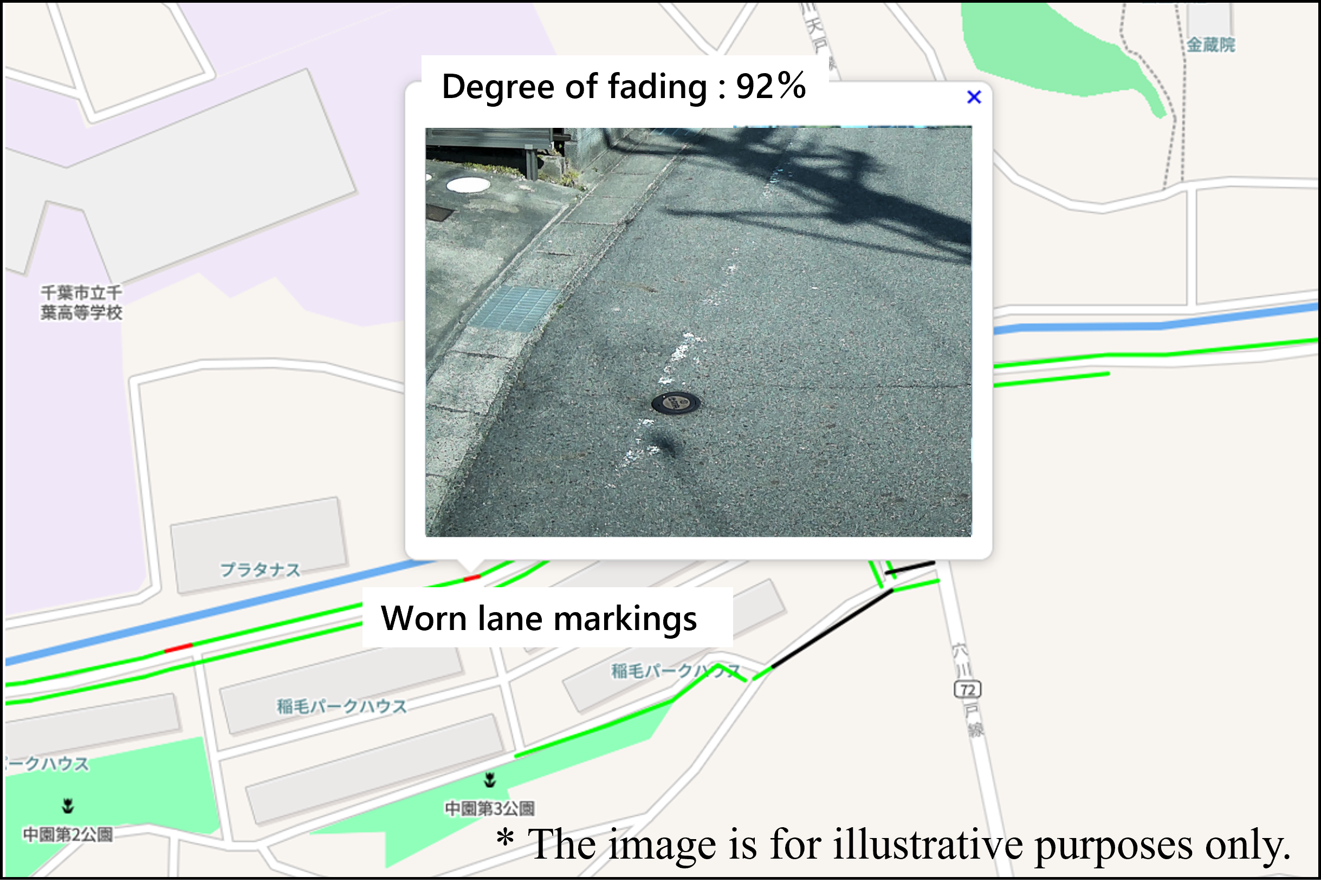
1. Detection of blurred lane markings (white lines)
On roads where vehicles equipped with Michi-log are traveling, the system uses AISIN's proprietary AI technology to calculate the degree of blurring of lane markings, and the results can now be displayed on a map along with photos of the road's white lines. Furthermore, the degree of blurring is color-coded and displayed on a map, making it possible to efficiently identify locations that need repairs. This enables road managers to detect damage to road markings at an early stage and quickly develop repair plans.
Road markings are extremely important for protecting children walking along school routes and for ensuring visibility for drivers at night and in bad weather. Furthermore, in recent years, proper lane markings have become necessary for vehicle driving assist technology (lane keeping function) to work effectively. The blurred-lane-marking detection function facilitates meeting these needs.
2. Specific location photographing function
Once the administrator has registered a location on the app, vehicles equipped with Michi-log will automatically take photos of that location while traveling, and the images can be displayed and managed on a map. This function allows local governments to easily inspect roads for abnormalities, such as distortions, by registering locations where deteriorated underground pipes are located. This will make it possible to use the technology to prevent and detect road collapses early, as road collapses have become a social issue. Furthermore, it can also be useful for checking for abnormalities in signs and other items under management, identifying unauthorized use of garbage stations, and even keeping an eye on vacant houses and elderly people living alone.
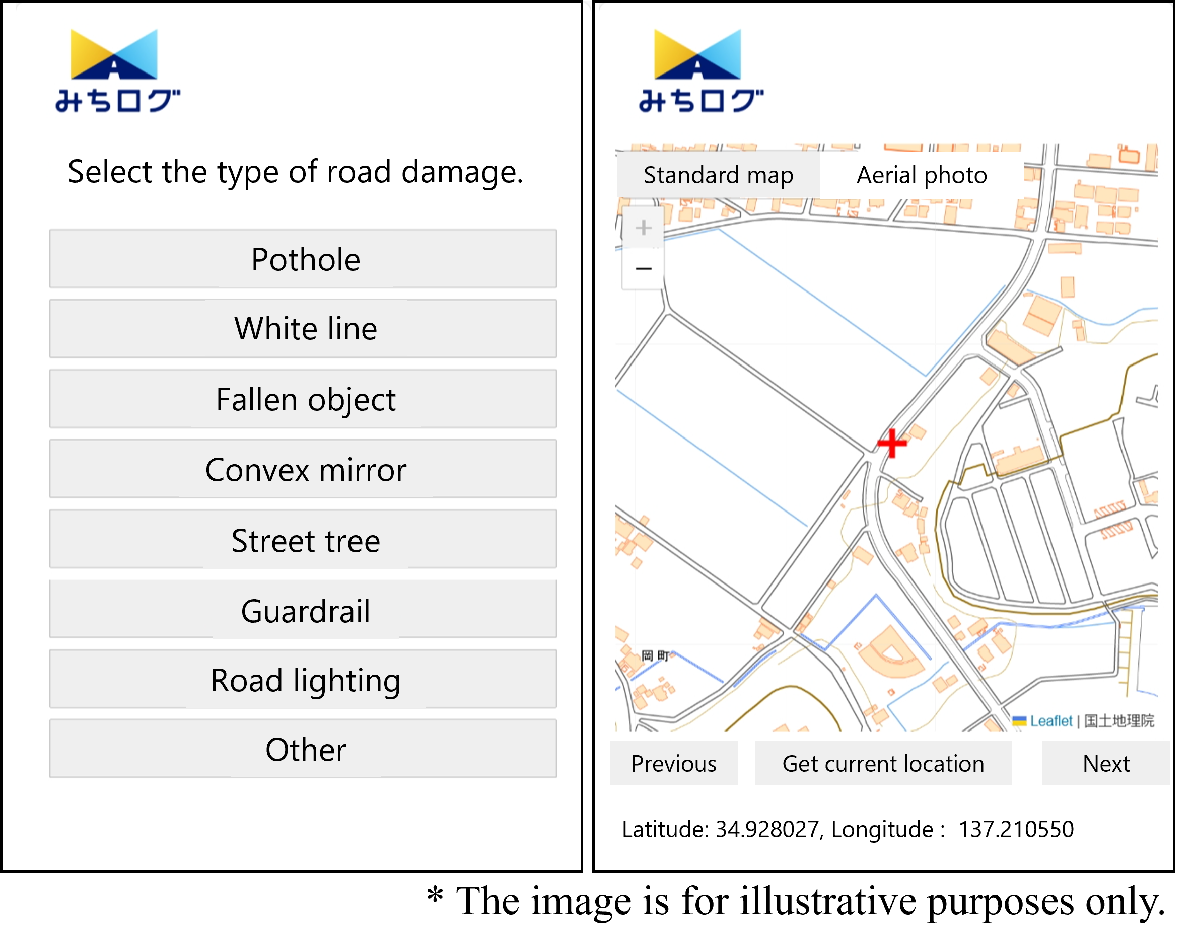
3. Reporting function using LINE
Conventionally, reports of road abnormalities from people were mainly made by phone. This function allows such reports to be received via LINE. The type of abnormality, details, photos, and location information can be easily registered, and the administrator can centrally manage the information on the app. This function will streamline the local government's call receiving and management operations and allow people to easily report emergency situations 24 hours a day.
Furthermore, the high durability and safety achieved through the development of in-vehicle devices makes it possible to install Michi-log permanently in commercial vehicles, enabling the device to be installed not only in conventional public vehicles but also in commercial vehicles such as taxis. Thus, the usability and comprehensiveness of the service have improved and help make road maintenance and management work of local governments more efficient.
AISIN will continue to promote the development of technologies to create a safer and more comfortable society, thereby striving to realize the AISIN Group Philosophy: Inspiring “movement,” creating tomorrow.
※ Road maintenance and management support service “Michi-log”
An AI-based comprehensive road management service that contributes to the support of plans for road repairs and to the implementation of measures by detecting road abnormalities, including potholes and cracks, based on driving data collected by vehicles and images taken by an in-vehicle camera.
<Related sites>
Tackling social issues through digital transformation (DX) | AI Think - Learning AISIN’s Now and Future